Incredible images: 21 photos of the world taken by satellite
Incredible images: 21 photos of the world taken by satellite. Discover and be dazzled by our planet!
In today’s article we have gathered some of the world’s best satellite photos to show you how truly surprising our planet Earth can be even kilometers away above the surface.
Earth is undeniably a planet full of life, with a diverse fauna and flora. However, satellite photos of the world show us how all this beauty above the surface can be even greater.
These incredible images were captured by Planet Labs’ SkySat satellites. The company operates several satellites in regular orbit around the planet, capturing and transmitting images in real time.
As there are thousands and thousands of photos of the world taken by satellite, we have gathered just 21 that will definitely leave you with your mouth open. Check them all out below!
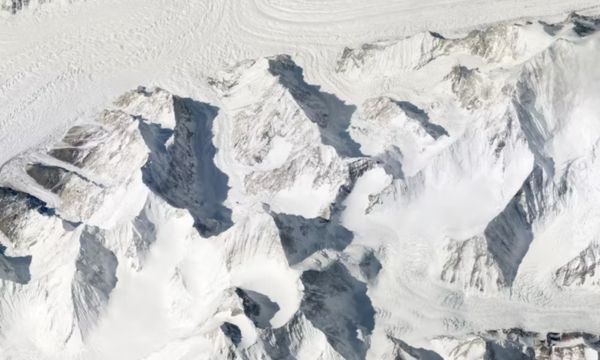
1- Gasherbrum Massif | Pakistan
Incredible images: 21 photos of the world taken by satellite
The term “Gasherbrum” means beautiful mountain and looking at the photo you can understand why it got its name. The image managed to capture a group of three mountains over 8,000 meters high, located in Pakistan.
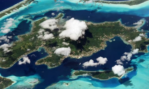
2- Bora Bora | French Polynesia
Incredible images: 21 photos of the world taken by satellite
This name may be familiar to you as it is a famous island that is characterized by its stunning natural beauty. However, this luxury tourist destination from space has a very particular appearance, as it is surrounded by a barrier reef. Furthermore, Bora Bora is a volcanic island that holds the remains of an extinct volcano.
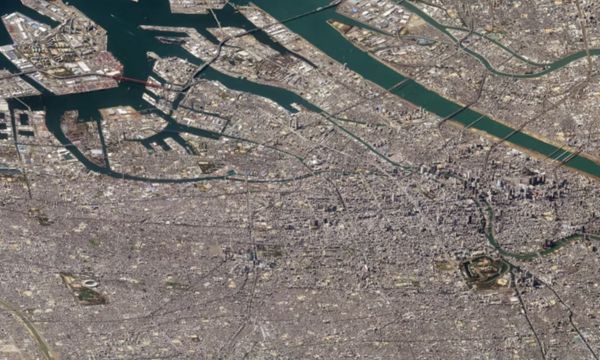
3- Osaka | Japan
Incredible images: 21 photos of the world taken by satellite
Osaka is one of the most populous cities in the world, home to more than 2.5 million people, but space is quite small despite the high population density. This is largely due to the fact that most of the land in the country is made up of mountainous and forested regions that are not suitable for living in them. As a consequence, coastal towns and cities have high population densities.
In the photograph captured by the satellite from more than 200 miles away, the giant skyscrapers appear tiny and completely insignificant.
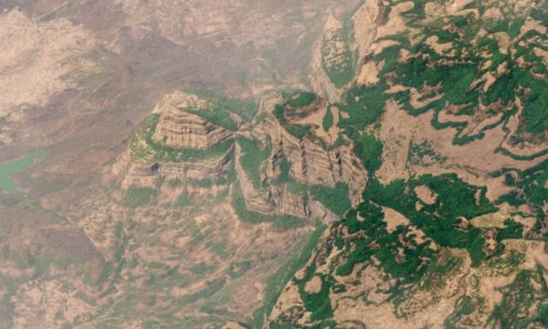
4- Deccan Traps | India
Incredible images: 21 photos of the world taken by satellite
At first glance it is truly impressive how from above we can see one of the greatest features volcanics of the Earth. Studies estimate that these features began to form more than 66 million years ago. We can see in the photograph the lava flows that are more than 2,000 meters thick.
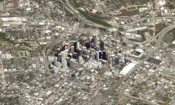
5- Houston | Texas
Incredible images: 21 photos of the world taken by satellite
Some photos of the world taken by satellite even appear to be fake. In this particular case, the skyscrapers in Houston are truly impressive. The skyline is filled with tall skyscrapers that tower over the city’s lower buildings. Still, if we look closely we can make out the open roof of Minute Maid Park, the local baseball stadium.
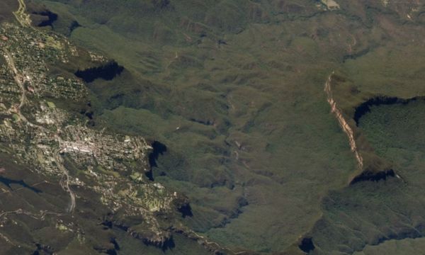
6- Blue Mountains | Australia
Incredible images: 21 photos of the world taken by satellite
The famous Blue Mountains are home to the Three Sisters Rocks, which are rarely seen from above. Just 30 miles northwest of the capital is Blue Mountain, with eucalyptus forests, steep mountain cliffs, waterfalls and numerous tourist attractions.A The area is also home to the Three Sisters rock formation, which is a natural occurrence created by the erosion of cliffs by rivers, wind and rain.
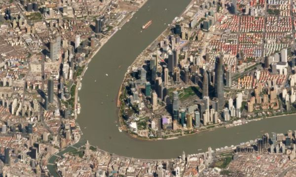
7- Shanghai | China
Incredible images: 21 photos of the world taken by satellite
Among the photos of the world taken by satellites, it is certainly one of the most incredible. Shanghai is a megalopolis and is the financial and economic center of China. It is a global city of great importance, known for its modern architecture, its busy port and its influence on international trade. Looking at the image, it is difficult to believe that it was captured by satellites.
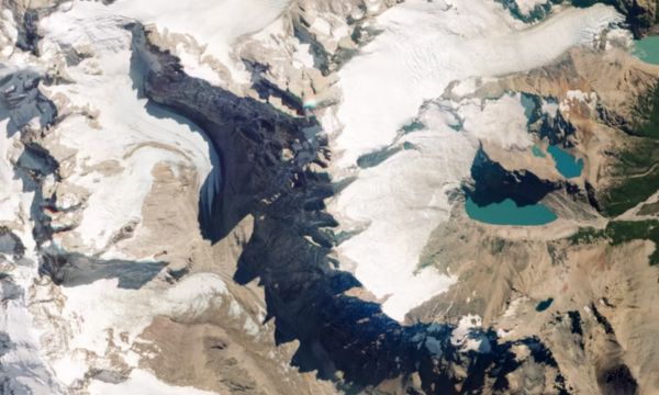
8- Nadir view of Mount Fitz Roy | Chile and Argentina
Incredible images: 21 photos of the world taken by satellite
Just looking at the photograph makes it impossible to appreciate the enormous extent of this mountain range, but it is still impressive. Even though we cannot see its true extent, it is unbelievable how the company has the ability to capture images of the planet from various angles, zoom levels, among others.
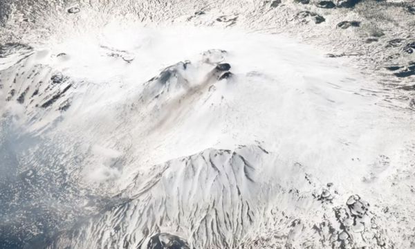
9- Mount Etna | Italy
Incredible images: 21 photos of the world taken by satellite
This impressive mountain is the second most active volcano on Earth, so don’t be fooled by the serenity that the image conveys! This volcano can be seen erupting on a regular basis, with its lava flow running down the snow-covered slopes.
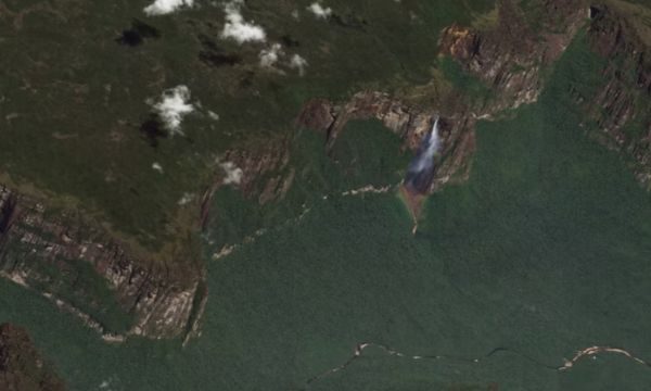
10- Angel Falls | Venezuela
Incredible images: 21 photos of the world taken by satellite
Angel Falls is the tallest waterfall in the world. It is a stunning natural wonder and was named after the American airline pilotJimmy Angel, who was the first to survive an emergency landing near the waterfall in the 1930s. The waters of the falls fall almost 1,000 meters high. In the image you can see the imposing waterfall on the edge of the mountain range, however from the top it looks tiny.
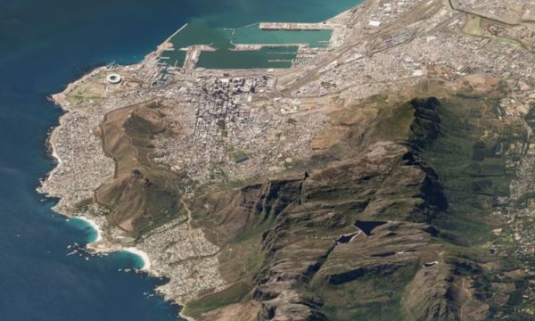
11- Table Mountain | South Africa
Incredible images: 21 photos of the world taken by satellite
Table Mountain is located in Cape Town, South Africa. This mountain formation is one of the area’s most prominent landmarks and a popular tourist spot. From the top, you can enjoy a panoramic view of the city and the National Park. Thanks to satellite images we can see from a new angle how natural beauty intertwines with man-made structures.
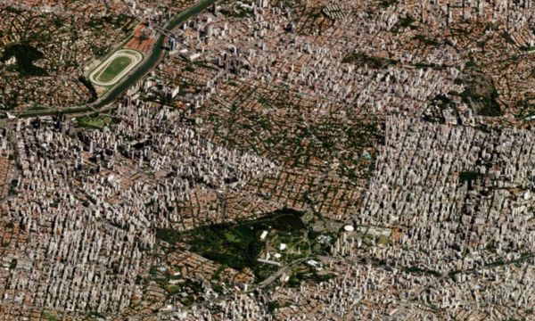
12- São Paulo| Brazil
Incredible images: 21 photos of the world taken by satellite
The city is home to a population of almost 12 million inhabitants, with a vast metropolitan area that extends over many square kilometers. This incredible photograph even looks like a 3D rendered map rather than an aerial image. The panorama is made up of blocks and blocks of tall apartments that stretch as far as the eye can see.
13- Riyadh| Saudi Arabia
Incredible images: 21 photos of the world taken by satellite
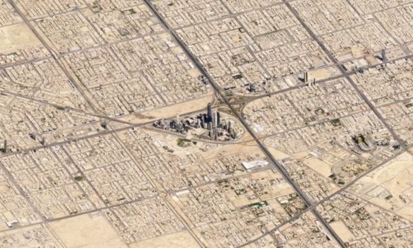
Here we have another of the photos of the world taken by satellite that really leaves us surprised. The view of the image is quite interesting and unusual. Riyadh is the country’s capital and is also well known for its small fragments of gigantic skyscrapers surrounded by smaller buildings. In the image, the Kingdom Center building is clearly visible, 302 meters high, which is located in the middle of the district.
14- Doha | Qatar
Incredible images: 21 photos of the world taken by satellite
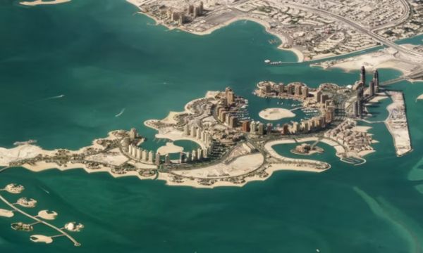
Contrary to what it seems, this image was not generated by AI (Artificial Intelligence)! The wonderful capital of Qatar is an island made by the hands of man and whose estimated population is 1.5 million inhabitants. The image above was so impressive that it could really intrigue anyone who saw it. In the photograph we can observe the landscape and the shadows cast by the huge skyscrapers.
15- Hurricanes of the Earth
Incredible images: 21 photos of the world taken by satellite
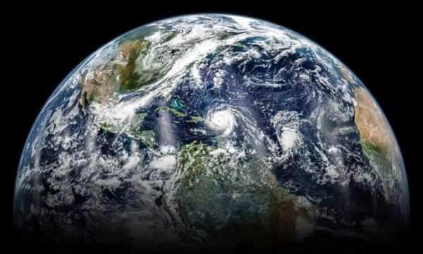
Our planet constantly faces extreme weather conditions. In this specific case, the image was captured in 2017, and shows us large hurricanes forming over the Atlantic Ocean. There is no doubt that it is an incredible view of our planet and the meteorological formations in formation.
16- Oblique view of Mount Fitz Roy
Incredible images: 21 photos of the world taken by satellite
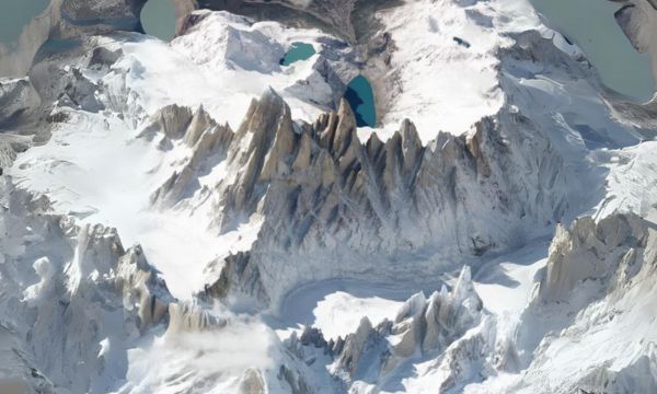
Looking at it like this, it almost looks like those fantastic films where kings and knights appear. It is truly a majestic thing to see! We can visualize how the mountains rise impressively over the lakes. These mountains are located more precisely in Patagonia, the border between Argentina and Chile, and make up the famous Andes Mountains.
17- Zion National Park | United States
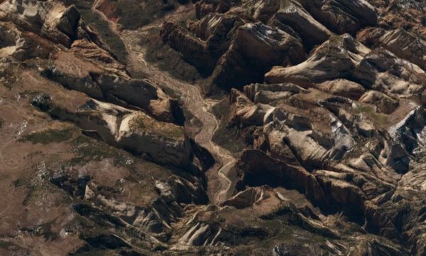
Incredible images: 21 photos of the world taken by satellite
If we observe from this angle, the park’s peaks and canals can be appreciated for their immense majesty. The gorge is 15 miles long, and in this specific image we can see patches of snow on the peaks and on the riverbed below. This region of Utah has a large variety of flora and fauna, with almost 300 different species including mammals, birds and reptiles.
18- Klyuchevskaya Volcano | Russia
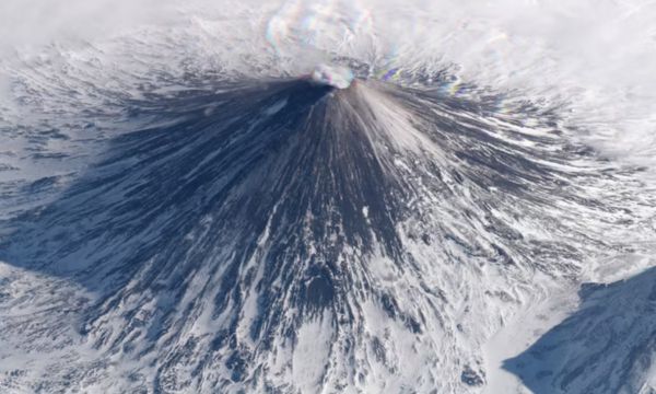
Incredible images: 21 photos of the world taken by satellite
Of the many photos of the world taken by satellite, this one is breathtaking. Records indicate that its first eruption occurred in 1697 and since then it has remained active. Klyuchevskaya Volcano is considered the highest mountain on the Kamchatka Peninsula.
19- BilBao | Spain
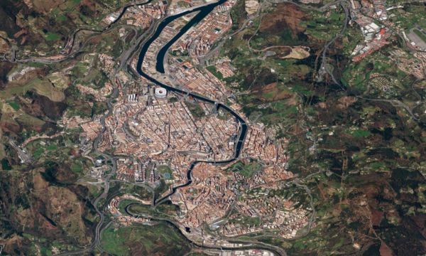
Incredible images: 21 photos of the world taken by satellite
Bilbao is a famous city located in the north and Spain, in the autonomous community of the Basque Country. It is also known for its rich history, culture, innovative architecture and renowned cuisine. In addition, the city is also considered an art center, with its renowned Guggenheim Museum Bilbao.
20- Sierrita Mine | United States
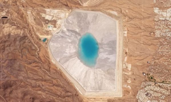
Incredible images: 21 photos of the world taken by satellite
This copper and molybdenum mine is located in the state of Arizona, in Cochise County. This mine is one of the most important copper mining operations in the region and is operated by Freeport-McMoRan, one of the largest mining companies in the world. It’s quite interesting how images like this can help engineers manage waste more efficiently.
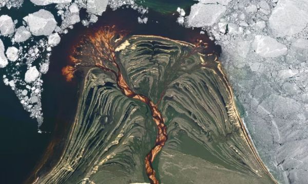
21- Athabasca River Delta |Canada
Incredible images: 21 photos of the world taken by satellite
The Athabasca River is one of the main rivers in the region and flows into Lake Athabasca, forming the delta. This area is of great ecological importance, housing a variety of wildlife, including waterfowl and fish. Incredibly, the photo was not manipulated and in fact the waters of the river were dyed brown by tannins along the way through the river. As a result we have this spectacular view!
 Natural Juices to Lower Glucose: Check out 6 Refreshing Recipes
Glucose control is essential for a healthy life, and finding natural ways to achieve this balance is a never-ending quest for many people. Among countless diet […]
Keep reading Practical Guide: Improving Baby’s Sleep in 5 Steps
One of the biggest challenges that parents have to face with the arrival of a new member in the family is the baby’s sleep. Without a […]
Keep reading Recommended Exercises for Diabetics: Stay Active
Recommended exercises for diabetics: Stay active and have better control of the disease. Exercising on a regular basis brings many benefits to our health, and especially […]
Keep reading